Enshi Prefecture
Karst Canyons, Tujia River Scenery and Giant Caves
In southwestern Hubei, the Enshi Tujia and Miao Autonomous Prefecture is famous for its deep karst canyons, emerald rivers and traditional Tujia and Miao villages. From the Enshi Grand Canyon and Pingshan Grand Canyon to the Daqing River, Suobuya Stone Forest and Tenglong Cave, the area has become a top destination for nature‑based and eco‑tourism in central China.
Enshi Grand Canyon – China’s “Oriental Colorado Canyon”
5A scenic area and unique karst museum
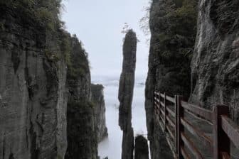
The Enshi Grand Canyon is a national 5A scenic area and a unique natural “museum” of karst landforms, where ground fissures, sinkholes and stone pillars coexist in one landscape. Often compared to the Grand Canyon in the United States, it features towering cliffs, pristine ecosystems and wide, dramatic views over the Qingjiang valley. Visitors can admire a 10‑km‑long cliff gallery, a “thousand‑foot” waterfall, hundreds of solitary peaks and deep, winding gorges, with countless viewpoints along the way.
Qixingzhai and Yunlong Ground Fissure
The core scenic area is divided into:
-
- Qixingzhai (Seven‑Star Fortress),
- Yunlong Ground Fissure (Yunlong Dijian).
- At Qixingzhai, cliff‑side walkways and plank roads lead past:
- the Cliff Corridor,
- A Line of Sky (narrow rock passage),
- the iconic Incense Pillar,
- Echo Valley,
- the Welcoming Pine,
- the Auspicious Cloud Torch.
The Yunlong Ground Fissure reveals a narrow river canyon. Stairs and boardwalks descend to the valley floor, where visitors pass cascades, rapids and sheer rock walls that sometimes nearly touch overhead. The area is also a cradle of ancient Ba culture and has over a thousand years of Tusi (native chieftain) traditions, adding depth for those interested in local history and ethnic heritage.
Climate: humid subtropical monsoon with mountain microclimates, average temperature about 13.4 °C, cool summers, mild winters and rainfall mainly from May to August – ideal for eco‑tourism and summer retreats.
Pingshan Grand Canyon – “Chinese Xishuangbanna” and glass‑like river
4A canyon in Hefeng County
Located in Hefeng County, the Pingshan Grand Canyon is a national 4A scenic area named after its flat‑topped peaks and steep cliffs. The canyon stretches about 18–20 km north to south, less than 5 km east to west, with elevation differences of over 1,000 m, forming a dense network of canyons, cracks and cliffs. Here, lush forests, vertical limestone walls, stone forests, waterfalls and a crystal‑clear river create scenery that has earned it the nickname “Chinese Xishuangbanna” or “Chinese Semporna”.
Clear river, and caves
Highlights include:
-
- a glass‑like river section where boats seem to float above the pebbled riverbed,
- numerous natural caves and underground river channels,
- rich, relatively undisturbed biodiversity with ancient trees and medicinal plants.
Uniquely, Pingshan offers China’s first AI‑based smart short‑video service in a scenic area: visitors scan a WeChat QR code, undergo facial recognition, then trigger cameras at different viewpoints to receive a personalised travel VLOG after the tour, which they can preview and download for a small fee.
Climate: mountainous humid subtropical monsoon, average temperature about 12 °C, cool summers, mild winters, rainfall concentrated in spring and summer – a perfect place for summer escapes and eco‑exploration.
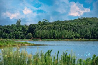
Daqing River – The “Mother River” of the Tujia
The Daqing River, in Sancha Town, is a national 4A scenic spot and was historically called Yishui. Flowing for roughly 400 km across Enshi Prefecture, it is revered as the “Mother River of the Tujia people” and is considered the most scenic and best‑preserved stretch of the Qingjiang River.
The Daqing River scenic belt in Enshi runs for 87 km, from the Fen River near Enshi City to Shuibuya in Badong County, and includes three gorge sections:
-
- Honghua Gorge,
- Qianpu Gorge,
- Butterfly Gorge.
Along the way, travellers see towering rock peaks, cliffs, waterfalls and stilted Tujia houses scattered between green mountains and clear water – a landscape widely praised as the “most beautiful river of the Tujia people”.
Climate: humid subtropical monsoon with mountain microclimates, average temperature around 15 °C, mild winters, cool summers and summer‑centred rainfall – ideal for boat trips and river excursions all year.
Luoyuanping – Roadless village and “hidden utopia”
Remote canyon village with 1,520 steps. In Banqiao Town, Luoyuanping is a remote village known for its dramatic canyon setting and unchanged rural lifestyle.
Surrounded by mountains on all sides, it features deep canyons, waterfalls and clear streams, earning the nickname “paradise outside the world”. The village sits in the basin of the Middle River, at the bottom of a canyon enclosed by cliffs. The elevation difference between Qiaowan Pass at the top and the valley floor is over 500 m. To reach Luoyuanping, visitors follow the “42‑Turn Trail”, a steep path about 1 km long with 1,520 stone steps and dozens of hairpin bends, preserving the village’s isolation and original landscape.
No road access and preserved way of life
Luoyuanping is the only roadless village in the area. Houses are mostly traditional stilted dwellings, and locals say the village closely resembles the utopia described in Tao Yuanming’s classic tale “Peach Blossom Spring”. The village lies in a karst doline and canyon fissure, facing the Enshi Grand Canyon over the ridge.
Climate: mountainous humid subtropical monsoon, average altitude around 1,700 m, average temperature near 10 °C, cool summers, cold winters, abundant rainfall – perfect for hiking and summer mountain stays.
Suobuya Stone Forest – Ordovician stone forest and oxygen bar
Ordovician stone forest on a karst plateau
The Suobuya Stone Forest, in Taiyanghe Township, is a national 4A scenic area covering about 21 km². Described as the world’s first Ordovician stone forest, it consists of dense clusters of limestone towers and pinnacles, arranged like a giant stone “gourd” surrounded by green hills. In the Tujia language, “Sobu” means “three”, and “Suobuya” roughly translates as “Three Passes”.
460‑million‑year karst evolution
Originally deposited as marine sediments during the Ordovician period about 460 million years ago, these rocks were later uplifted and sculpted by karst processes – dissolution, water erosion and weathering – into today’s spectacular formations. At an average altitude above 900 m, Suobuya has a humid subtropical monsoon climate with:
-
- mild winters,
- cool summers (around 22 °C),
- lush vegetation and abundant wildlife.
Nicknamed both a “crowned stone forest” and a “natural oxygen bar”, it has an average annual temperature around 15 °C, with summer‑centred rainfall, making it ideal for summer holidays and geological exploration.
Enshi Earth Center Valley – Karst gorges and cultural experience
Alpine karst valley with themed zones
The Enshi Earth Center Valley, in Gaoping Town, is a 4A scenic area combining:
-
- high‑mountain gorges,
- cultural and geological experiences,
- leisure resorts,
- outdoor sports,
- RV camping and study tours.
Its landscapes are shaped by alpine karst with Triassic‑age limestone cliffs and valleys formed around 250 million years ago.
The area features themed zones such as:
-
- the Earth Core Gorge,
- the Earth Core performance show,
- the Ancient Ba Salt Road, highlighting historic trade routes.
The valley also preserves cultural resources such as an Homo erectus site, Tujia culture and geological heritage, making it an attractive destination for both sightseeing and educational trips.
Climate: humid subtropical monsoon, significant vertical differences, annual average about 15 °C, with mild winters, cool summers and summer‑focused rainfall; dense forests make it perfect for summer retreats and karst discovery.
Tenglong Cave – Giant karst cave in the Enshi–Tenglong Global Geopark
One of China’s largest cave systems. Tenglong Cave, in Lichuan City at the upper reaches of the Qingjiang River, is a national 5A scenic spot and one of China’s largest known karst caves. Its entrance measures about 74 m high and 64 m wide, leading to a network of roughly 60 km of mapped passages across five cave levels.
The scenic area includes:
-
- the Water Cave,
- the Dry Cave,
- Catfish Cave,
- Cool Wind Cave,
- Duxiazhai Village,
- the Three Dragon Gates,
- the Huaxian sinkhole,
- as well as towering karst cliffs ideal for rock climbing and outdoor survival training.
Part of the Enshi–Tenglong UNESCO Global Geopark
On 27 March 2024, the UNESCO Executive Board approved the inclusion of the Enshi Grand Canyon–Tenglong Cave Global Geopark into the UNESCO Global Geoparks Network, confirming the outstanding geological importance of the area. Tenglong Cave lies in a continental humid subtropical monsoon zone with strong mountain microclimates, maintaining a cool internal temperature of around 14–18 °C all year. With cool summers and rainfall concentrated in summer months, it is a prime destination for both summer holidays and cave exploration.